Course Outline Environmental Studies home Environmental Engineering Technology home

The Hydrological System

Picture by Elementary Science Teacher Resource Book,
Utah State Office of Education
  1. Water in Circulation
    1. The hydrologic cycle

    Where is the water?

    Fraction of total

    Oceans

    97.3%

    Polar or mountaintop ice

    2.1%

    Groundwater

    0.6%

    Freshwater Lakes

    0.009%

    The atmosphere (vapor)

    0.001%

    Rivers

    0.0001%

  2. Precipitation
  3. Runoff
    1. Effects of soil
        • soil characteristics greatly affect the degree of runoff versus infiltration
          • clay content reduces infiltration, especially after the ground is saturated with water (which swells the clay)
            • sandy soil or friable loams, both of which have low clay content, have higher rates of infiltration
          • more densely compacted soils have lower rates of infiltration
            • note: rainfall can actually compact soil
            • rainfalling directly on soil also tends to plug the opening in the ground with fines from near the surface (like espresso grind coffee in a melitta filter)
          • waterlogged soil has a lower rate of infiltration than dry soil
            • frozen soil has almost no infiltration (it may actually be coated with ice
          • thus the timing and dynamics of a storm event can have a great influence on the proportion of runoff
            • generally speaking, longer or repeated rains result in more runoff
          • human development of an area usually has a dramatic effect on increasing runoff
            • paving and roofs have essentially no infiltration
            • one of the engineering calculations that must be done when planning a development is the excess flood flow--this must be taken into account
            • diverted stormwater may have substantially poorer quality than native runoff (metals and oils etc from the streets and yards)
              • commercial and industrial establishments that discharge stormwater at a point are now subject to the restrictions of categorical wastewater discharge permit
    2. Effects of vegetation
        • vegetation can greatly increase the rate of infiltration
          • hold water in place, buffer the release of water to the groundsurface
          • shield the soil surface from some of the effects of compaction by rainfall
        • clear cutting a forest can increase runoff and erosion disastrously, as can overgrazing and improper cropping
          • proper management reduces the effects
          • in fact, well conducted forestry (including some clear cutting) can increase the amount of snowmelt which is available for human use without dangerously increasing erosion
          • plowing along hillside contours (conservation tillage) tends to slowdown runoff and thus decrease erosion and increase infiltration
            • bare soil is bad
    3. Erosion and rivers
        • water flow in streams is often turbulent (ie, not laminar or in smooth lines parallel to the stream bed)
          • different flow velocities will lift particles of different sizes
            • generally, smaller particles will be lifted by lower velocities
            • but, clay and silt (<0.06 mm) can be harder to erode
              • can be tightly packed (consolidated)
              • may not stick up into the flow enough
          • suspended matter abrades rocks etc
          • as the river cuts a stream channel, the
          • some material is dissolved by surface water passing over it
        • the process of erosion gives rise to stream beds
          • a drainage pattern develops like the veins on a leaf (assuming the surface is uniformly erodable-irregularities change the pattern (trellis or rectangular)
          • the entire area from which a river and its tributaries draw runoff is called a drainage basin or watershed
            • the divisions between drainage basins are ridges called topographic divides
            • these can be drawn on topo maps by always drawing at right angles to the contours
          • a fast young stream cuts rapidly and sharply into the rock (V-shaped cross section)
            • these narrow valleyed rivers have waterfalls and rapids caused by sudden drops in elevation along the stream bed
              • may be caused by erosion (Niagara) or glaciation (Yosemite)
            • slope wash and mass movement (collapse) of the valley walls tend to flatten the walls of the valley
          • a more mature river
            • cuts more laterally, increasing the number and size of side canyons
            • deposits some eroded material in the base of the valley
            • alternatively, the valley itself can be broadly eroded to form a plain
          • an old river has a broad floodplain at the base of the valley, the channel of the river can meander across it
            • the periodic flooding of the river enriches the floodplain with nutrients carried by the swollen river
            • the bed of the river can actually sit above the surrounding floodplain, with the stream channel separated by natural levees
            • the low-lying flood plains are also popular for housing, which can be a problem in the rainy season
              • building dikes can make the problem worse downstream
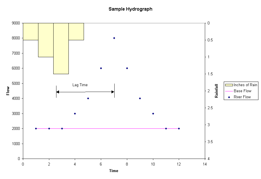
        • the base flow of a river is fed by springs
          • in a rain storm flow increases, the more widespread a storm is (over the drainage basin) the more flow increases
          • the plot of flow of a river is called the hydrograph
    4. Flood protection
        • planning based on the 100 year (or other) flood
        • flood control or management measures:
          • reducing peak flows
          • dams
          • land use controls
          • early warning systems
          • insurance (often from Uncle Sam)
  4. Lakes
    1. Stratification
        • the slow moving water of lakes is not necessarily mixed by turbulence, thus there is an opportunity for layers to form
        • cool water sinks, warm rises
          • in summer (if the lake is deep enough), the lake separates into the warm epilimnion and the cool hypolimnion
          • the two layers are separated by a thermocline
            • you have felt this with your toes when swimming
            • sometimes you can pick it up with a fishfinder
          • the hypolimnion is isolated from the surface, ie oxygen thus the bottom of the lake can become anoxic due to aerobic decomposition
            • this condition is deadly to fish
            • the anaerobic environment favors reduction reactions
              • sulfide can form
              • solubility of metals and nutrients is affected
          • in winter, the stratification is slightly different with ice and cold water on top and water at 4° C on the bottom
            • if photosynthesis stops due to snow and ice cover, there can be anoxia under the ice
          • in spring and fall, lakes turnover
            • important in the seasonal changes in the lake ecosystem
            • have affects on the distribution and movement of nutrients and metals
  5. Groundwater
  6. Limestone & Sinkholes
  7. Glaciers
  8. Water Supply
    1. Water rights
      • riparian ("river-ian"): all those who own land fronting on a river are entitled to the water; your riparian rights protect you from those upstream
        • based on English common law; this theory is used for water rights in most of the eastern US (where water is plentiful and cheap)
        • no one may deprive those downstream of their use of the water
        • conversely, you can't flood out those downstream (don't increase or decrease useful flow)
      • prior appropriation
        • this theory is used for water rights in most of the western US (where water is scarce and expensive)
        • first come, first serve (and shoot the guy who comes after you); your right to use water is based on historical precedent
    2. Transbasin diversion of water
      • a raindrop falling in one watershed ends up in another
      • New York City is not in the Delaware River watershed, yet it draws its water supply from there
        • there is an agreement between the city and the Delaware Basin Commission (this is a sort of prior appropriation)
        • other large cities (such as LA) divert water from faraway
    3. Irrigation
      • if rainfall is less than 20 inches per year, farming is generally not feasible without irrigation
        • irrigation consumes a lot of water
          • about 200 to 300 gallons of water have to be taken up by a tomato plant to produce one pound of tomatoes
          • more water than that must be poured onto the plants for them to take up that much water
          • a good portion of that poured onto the ground evaporates
          • irrigated soil becomes saline form salts in the irrigation water; soil can have nutrients leached out of the root zone; leached nutrients and salts can contaminate the groundwater
        • irrigation of feed grain and watering of livestock consumes a large amount of the water used in the US
          • about 2500 gallons of water are required to produce one pound of hamburger
    4. Water uses (data for 1995 from the USGS)
      • as you can see from the table, direct water use is approximately 100-120 gallons per person per day
      • the largest use of water is for irrigation and livestock watering
        • this usage is almost two thirds consumptive (consumed water is not returned to the environment in reusable form, instead it is evaporated or contaminated)

    US Daily Water Use by Sector for 1995

    Category of Use

    per capita daily use

    fraction consumed

    Domestic

    86 gallons

    26%

    Commercial

    36 gallons

    14%

    Industrial

    78 gallons

    16%

    Thermoelectric

    500 gallons

    2.5%

    Agricultural

    528 gallons

    61%


Return to: Top Course Outline Environmental Studies Environmental Engineering Technology


ANTHONY G BENOIT
ROOM 201B
(860) 885-2386

abenoit@trcc.commnet.edu